
Travel
Tonghou Trail: History, Routes, and Travel Tips
The Tonghou Trail is one of the most scenic and historic hiking routes in northern Taiwan. Located in Wulai District, New Taipei City, the trail connects to Jiaoxi Township in Yilan County and follows the Tonghou River through lush forests and mountain valleys. It is known for its accessible terrain, beautiful riverside spots, and rich cultural history.
This guide will give you all the essential information about the Tonghou Trail, including its history, main routes, hiking conditions, and travel tips for planning your trip.
About the Tonghou Trail
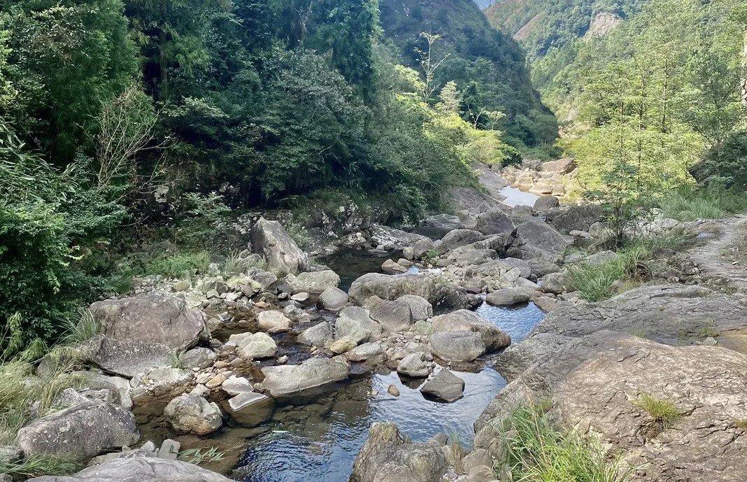
The Tonghou Trail is approximately 23 kilometres in length if completed as a full through-hike from Wulai to Jiaoxi. The elevation is modest at around 294 metres, making it suitable for both beginners and experienced hikers. The trail is divided into three main sections:
| Section | Distance | Difficulty Level | Key Features |
| Tonghou Forest Road | 12 km | Easy | Wide path, gradual slope, riverside views |
| Tonghou Traversing Trail | 6.8 km | Easy-Moderate | Single-track path, bridges, river access |
| Final Forest Road (Jiaoxi Side) | 3 km | Easy | Scenic views, double-track path |
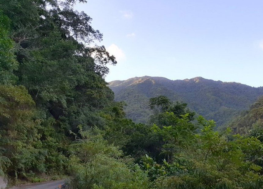
The area is part of the Snow Mountain (Xueshan) Range and features low-altitude broad-leaved forests, rich wildlife, and numerous river access points.
History of the Tonghou Trail
The Tonghou Trail has a long history as both a cultural route and a transportation link.
Indigenous Origins
- The trail was first created by the Atayal people, one of Taiwan’s largest indigenous groups.
- It served as a hunting route and a trade path between communities.
- Tonghou is one of three major historic trails used by the Atayal in northern Taiwan, along with the Fuba Traversing Historic Trail.
Japanese Occupation
- During the Japanese colonial period (1895–1945), the trail was converted into a forest road for logging.
- Trolleys were installed to transport timber from the valleys to Wulai.
- After World War II, the trolleys were dismantled, and the road was adapted for vehicles.
Modern Development
- In recent decades, the trail became a popular hiking and leisure route.
- It was damaged in 2015 by Typhoon Soudelor and closed for several years.
- The trail reopened in 2021 after restoration, becoming a lesser-known but rewarding hiking destination for locals and visitors.
Also Read: What Are Some Budget-Friendly Travel Tips for Europe?
Trail Sections in Detail
1. Tonghou Forest Road (12 km)
- Starting from Xiaoyi village in Wulai, hikers enter the Tonghou Forest Road at the 1 km marker.
- The first half of this section is paved, while the second half is a mix of compact soil and asphalt.
- Landmarks include a large waterfall and continuous views of the Tonghou River.
- The walk is mostly flat or gently downhill and takes about 2.5–3 hours to complete.
2. Tonghou Traversing Trail (6.8 km)
- Begins at the 13 km marker of the forest road.
- Narrower paths with stone steps, small bridges, and occasional rope-assisted slopes.
- Includes river crossings that may require removing footwear depending on water levels.
- Notable features: an old suspension bridge site, a metal staircase leading to the river, and several good picnic spots.
- Takes around 3 hours to hike with time for breaks.
3. Final Forest Road (Jiaoxi Side) (3 km)
- Double-track dirt road that descends toward the pick-up area.
- Mostly shaded with occasional open viewpoints over Yilan County and Turtle Island.
- Takes 30–40 minutes to walk.
Difficulty Level and Timing
The Tonghou Trail is considered easy to moderate in difficulty. It has a few short climbs and uneven sections, but there are no technically challenging parts.
- Degree of difficulty: 2 out of 5
- Time required for the full route: Around 6 hours
- Trail type: Linear (can be done as out-and-back or through-hike)
Best Time to Visit
The Tonghou Trail can be hiked year-round, but some seasons are better than others:
| Season | Conditions | Pros | Cons |
| Spring (March–May) | Mild weather, blooming vegetation | Comfortable temperatures, good water flow | Occasional rain |
| Summer (June–Sept) | Hot and humid | Swimming is possible, with lush scenery | Afternoon thunderstorms, high heat |
| Autumn (Sept–Nov) | Cool, dry | Best for long hikes, clear views | Popular with local hikers |
| Winter (Dec–Feb) | Mild to cool | Fewer crowds | It can be damp and rainy |
How to Get There
One challenge with the Tonghou Trail is the lack of public transport to either trailheads.
From Taipei to Wulai Side
- Take the Taipei Metro Green Line to Xindian Station.
- Transfer to Bus 849 to Wulai (about 30–40 minutes).
- From Wulai, hire a taxi or arrange private transport to the Xiaoyi village traffic gate (1 km marker).
- Taxi cost: NT$300–NT$500 one way.
- Uber from Xindian to the gate: Around NT$600.
From Jiaoxi Side
- Private transport or arranged pick-up is required.
- Some tour operators offer through-hike transport from Wulai to Jiaoxi.
What to Bring
As the trail has no facilities, hikers should be self-sufficient. Recommended items include:
- Water (1.5–2 litres per person)
- Snacks or lunch
- Sunscreen and hat
- Rain gear (weather can change quickly)
- Swimsuit and towel in summer
- Hiking shoes suitable for wet and uneven terrain
- Offline map or GPX file (mobile reception is limited)
Safety and Trail Conditions
- No permits are required to hike the Tonghou Trail.
- The trail can become slippery after rain, especially on stone steps and wooden bridges.
- Afternoon thunderstorms are common in summer; plan to hike early in the day.
- Be cautious around fast-flowing sections of the river during heavy rain periods.
Camping and Tonghou River Campground
For hikers who want to extend their trip, the Tonghou River Campground is a good choice. It is located about 13 kilometres along the Tonghou Forest Road, near the trailhead of the Tonghou Crossing Trail. The area is well-maintained and surrounded by natural beauty, making it popular for camping and outdoor activities.
Features of Tonghou River Campground
- Suitable for picnics, water activities, and hiking
- Rich biodiversity with butterflies, birds, fireflies, and frogs during warmer months
- Accessible only by personal transport
- Limited parking space available
- No large stores or facilities nearby, so bring supplies in advance
Check out: How to Travel the World on a Weekend: 48‑Hour Itineraries
Connected Trails and Peaks
The Tonghou Trail is connected to several other trails in the Wulai and Yilan mountain areas, making it possible to extend your adventure. Some hikers combine Tonghou with nearby peaks or sections of the Snow Mountain Range.
Popular Connected Trails
- WuTong Trail – A shorter trail offering more river views
- Datong Hiking Trail – A moderate climb with panoramic views
- Tonghou River Source Trail – A quieter route leading deeper into the river valley
Notable Peaks Nearby
| Peak | Height | Special Notes |
| Mt. Dajiaoxi | 1,161 m | Requires a permit; scenic ridge views |
| Mt. Xiaojiaoxi | 1,147 m | Accessible from the Tonghou side |
| Mt. Hongludi | 1,166 m | Class One Triangulation Stone, 360° views |
| Mt. Ayu | 1,420 m | Part of the Lanyang Five Famous Mountains |
Cultural and Historical Context
The Tonghou Trail has cultural importance due to its connection to the Atayal people, one of Taiwan’s largest indigenous groups. They used this route for:
- Hunting trips into the mountains
- Trading goods between communities
- Seasonal migration
During the Japanese occupation, the trail was modernised to transport timber. Remnants of that period, such as old roadbeds and bridge foundations, can still be seen.
The name “Tonghou” means “behind the bucket,” referring to Mt. Datong. This traditional name reflects the area’s geography and history.
Sample Hiking Itineraries
1-Day Through-Hike from Wulai to Jiaoxi
- Start early from the Xiaoyi village traffic gate
- Hike the 12 km Tonghou Forest Road (2.5–3 hours)
- Continue on the 6.8 km Tonghou Traversing Trail (3 hours with breaks)
- Finish with the 3 km final forest road to the pick-up point (30–40 minutes)
- Arrange transport in advance from Jiaoxi
Half-Day Out-and-Back from Wulai
- Hike 5–7 km along the Tonghou Forest Road
- Spend time by the river for lunch or swimming
- Return along the same route
- Suitable for a more relaxed pace
Overnight Camp and Hike
- Arrive at Tonghou River Campground in the afternoon
- Camp overnight and enjoy evening wildlife
- Begin the hike early the next morning for cooler temperatures
Travel Tips
- Plan Your Transport
- The lack of public transport means you should book a taxi, private car, or join a guided trip.
- If doing a through-hike, arrange a pick-up at the endpoint in advance.
- Check the Weather
- Heavy rain can make river crossings difficult or dangerous.
- In summer, start early to avoid thunderstorms.
- Pack Light but Smart
- Although the trail is not technically challenging, proper footwear and sufficient water are essential.
- In summer, swimming gear is a nice addition.
- Leave No Trace
- There are no waste facilities on the trail.
- Carry all trash back with you to protect the environment.
- Know Your Route
- Download a GPX file for navigation.
- Some sections have limited or no mobile signal.
Best Times to Photograph the Trail
The Tonghou Trail is photogenic year-round, but certain times offer better conditions:
- Spring – Fresh greenery and high river levels for waterfall shots
- Summer – Bright, lush scenery with clear swimming spots
- Autumn – Crisp air and fewer insects
- Winter – Misty Forest views and quieter trails
For the best lighting, early morning and late afternoon are ideal. The middle of the day is good for capturing the blue-green colour of the river.
Nearby Attractions
If you have extra time after your hike, there are several attractions near the Tonghou Trail:
- Wulai Old Street – Hot springs, local snacks, and Atayal cultural displays
- Jiaoxi Hot Springs – Public foot baths and private spa resorts
- Sandiaojiao Lighthouse – Located at Taiwan’s easternmost point
- Sanjiaolun – Another peak in the Lanyang Five Famous Mountains
Final Thoughts
The Tonghou Trail offers a unique mix of history, culture, and nature. It is accessible enough for casual hikers but still rewarding for experienced outdoor enthusiasts. The combination of riverside paths, indigenous history, and scenic views makes it one of the most worthwhile trails in northern Taiwan.
Whether you choose to hike the full route, explore a section, or camp by the river, the Tonghou area is a place worth visiting more than once. With good preparation and respect for the natural environment, it can be an unforgettable part of your Taiwan hiking experience.
Read about: On the Road to Adventure: A First-Timer’s Guide to Travel Trailers


Large Format Kitchen Tiles: Redefining Space and Visual Continuity

What Exactly Happens After a Peace Bond Expiration?

What is PuzuTask Com? A Complete Guide for Beginners

Personal Accident Cover: Why This is the Most Important Security for Every Rider